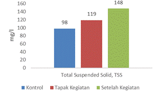
Mining activities by the community on the border of the Paguyaman River cause pollution in river waters. The direct impact can be seen in the quality of the waters. This study aimed to analyze the water quality of the Paguyaman River in the rock mining area of Motoduto Village, Boliyohuto District. This research was conducted in 2022 on the Paguyaman River. Water sampling was carried out in three places, namely before the mine site as a control, at the site of illegal mining activities during activities and after the mining site. Water quality parameters include brightness, pH and Dissolved Oxygen (DO). Total dissolved solids (TDS), Total Suspended Solid (TSS), temperature and ammonia, Biological Oxygen Demand (BOD) and Chemical Oxygen Demand (COD). The measurement results will be displayed in graphical form and discussed descriptively concerning the PP quality standards No. 22 of 2021 (Appendix VI). The laboratory analysis showed that the TSS and Surfactant parameters passed the water quality standards for Class II. The concentration of TSS in the control location was 98 mg/l and 0.009 mg/l surfactants. The concentration of TSS around the mine site is 119 mg/l and the Surfactant is 0.02 mg/l. The concentration of TSS after the mine site was 148 mg/l and the Surfactant was 0.021 mg/l. The TSS quality standard for Class II River water is 50 mg/l and the Surfactant is 0.001 mg/l. The concentration of TSS in the control location was 98 mg/l and 0.009 mg/l surfactants. The concentration of TSS around the mine site is 119 mg/l and the Surfactant is 0.02 mg/l. The concentration of TSS after the mine site was 148 mg/l and the Surfactant was 0.021 mg/l. The TSS quality standard for Class II River water is 50 mg/l and the Surfactant is 0.001 mg/l. The concentration of TSS in the control location was 98 mg/l and 0.009 mg/l surfactants. The concentration of TSS around the mine site is 119 mg/l and the Surfactant is 0.02 mg/l. The concentration of TSS after the mine site was 148 mg/l and the Surfactant was 0.021 mg/l. The TSS quality standard for Class II River water is 50 mg/l and the Surfactant is 0.001 mg/l.
Keywords
Water Quality
Mine
River Water Pollution
INTRODUCTION
The utilization of natural resources must be carried out optimally to realize the fulfilment of human needs, which is the goal of development. One of the natural resource forms is rock mining. According to Supramono, Indonesia is one of the countries with the most considerable global mining potential. Based on Law No. 4 of 2009, mining activities are part or all starting from general investigations, exploration, feasibility studies, construction, mining, processing and refining, transportation and sales and post-mining activities.
Data from the Investment Service, ESDM Gorontalo Province for October 2021 shows that a total of 39 permits for rock mining (SIPB) for both individuals and companies in the Gorontalo Regency area, 14 permits that have expired or have not been extended, a total of 25 permits that are still operating or location. The rock mining business operating in Gorontalo Regency, in addition to supplying materials for both community needs and government/private construction work in Gorontalo Regency, also supplies material to the City of Gorontalo, Boalemo Regency and North Gorontalo Regency, so that the existence of a rock mining business must be maintained and pay attention as a material supplier for construction work and is one of the supporting factors for development in the province of Gorontalo.
As time goes by, rock mining activities are increasingly being carried out due to the significant demand for raw materials for the benefit of the community and development by the government and the private sector. In general, rock mining sites in Gorontalo Regency are located near or crossing community residential areas, so mining activities and the community are two components that influence each other.
Rock mining activities around riverbanks can cause a decrease in environmental quality with changes in land cover; even in significantly changing conditions, it can cause flooding during the rainy season [1-3]. Management of land use, including rock mining activities, can cause pollution loads around the activity site to increase it can affect environmental quality and increase the potential for erosion and sedimentation in watersheds [4-6].
This mining activity has an impact on the surrounding community, both positive, including creating jobs and improving the economy and negative impacts, such as decreasing environmental quality and sedimentation problems which impact public health. According to [7], one of the negative impacts of community economic activities is when these activities negatively impact the environment, which ultimately increases the potential for government financing due to environmental damage. The interaction between the two is something that cannot be avoided because they are in the same environment.
Mining activities have an impact on the surrounding community. The impact can be positive impact as well as negative impact. Negative impacts caused by mining activities must be managed optimally. Research on "The Impact of Rock Mining Activities on Environmental Quality in Gorontalo District" will identify and analyze the impacts caused by rock mining activities. Based on the formulation of the problem that has been described, the purpose of this study is to analyze the physical and chemical quality of the waters around rock mining sites in Gorontalo Regency.
MATERIALS AND METHODS
Research Sites
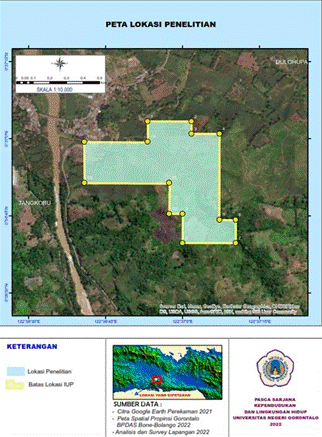
The research location is on the Paguyaman River, especially around the rock mining site in Motoduto Village, Boliyohuto District, Gorontalo Regency. Sampling location 1 is at coordinates N 0° 37'20.16", E 122° 36'28.68". Location 2 is at coordinates N 0° 37'4.02", E 122° 36'35.75" and sampling location 3 is at coordinates N 0° 37'4.03", E 122° 36'35.72". The research location map is shown in Figure 1.
Figure 1: Research Location Map
Data Analysis
Data analysis was carried out by comparing the results of laboratory analysis with water quality standards, namely Appendix VI of Government Regulation Number 22 of 2021 concerning Implementation of Environmental Protection and Management.
RESULTS AND DISCUSSION
Here are given some physical parameters of Paguyaman River quality tests (Table 1).
Table 1: Laboratory Test Methods for River Water Quality Parameters
No
Parameter
Test Method
1
Temperature
5.5-IK-GQA-003
2
Total Dissolved Solids, TDS
SNI 06-6989.27-2005
3
Total Suspended Solids, TSS
SNI 06-6989.3-2004 Chemical
1
pH
SNI 06-6989.11-2004
2
Biological Oxygen Demand, BOD5
SNI 6989.72:2009
3
Chemical Oxygen Demand, COD
SNI 6989.2:2009
4
Dissolve Oxygen, DO
SNI 06-6989.14-2004
5
Nitrogen, Nitrate as N (NO3-N)
5.4-IK-GQA-WQ-043
6
Nitrogen, Nitrite as N (NO2-N)
SNI 06-6989.9-2004
7
Surfactants, MBAS
SMEWW 22nd ed. (2012):5540 C
8
Oil and grease
SNI 06-6989.10-2011
9
Total Phosphate as P
7.2-IK-GQA-WQ-062
Temperature
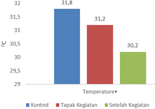
Chemical and biological processes in a body of water are determined by temperature. [8-10]. Based on the research results, it was found that the temperature values tended to fluctuate. However, the changes were not too significant, with the lowest temperature value being 31.20C and the highest being 31.80C (Figure 2).
Figure 2: Temperature measurement at the sampling point
Observations around the Paguyaman River area found much-reduced vegetation, especially tree species. The existence of trees can protect the river from exposure to sunlight. Accordance with previous water quality studies stated that the temperature pattern of aquatic ecosystems is influenced by various factors such as the intensity of sunlight, heat exchange between the water and the surrounding air, geographical altitude and also the canopy cover factor (coverage by vegetation) of trees [11-13]. If referred to the river water quality standards based on PP number 22 of 2021, the temperature value of the Paguyaman River waters is in the normal category because there is no difference from the air temperature above the water surface.
Total Dissolved Solids (TDS)
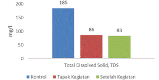
Based on the results of TDS measurements, the lowest value was 83 mg/l and the highest was 185 mg/l (Figure 3). TDS or dissolved solids consist of organic and inorganic compounds in water. They have identified several inorganic compounds dissolved in water, such as detergents and shampoos, which are liquid waste from households or settlements around the Paguyaman River. The solids dissolved in the water are in the form of inorganic chemicals and dissolved gases. Water containing excess amounts of solids causes an unpleasant taste, causes nausea, causes heart attacks (cardiac disease) and toxaemia in pregnant women [11]. Following water quality standards, according to PP No. 22 of 2021, the TDS for Class 2 is 1. 000 mg/l, so the TDS value in the Paguyaman River is still below the set quality standard value. According to [6], pollution that occurs in water bodies is generally caused by an increase in organic waste originating from community activities.
Figure 3: Measurement of Total Dissolved Solid (TDS) at the Sampling Point
Chemical Parameters of Paguyaman River Quality
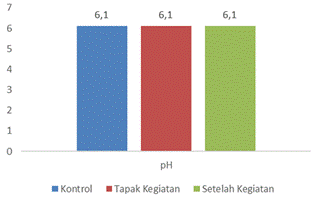
pH Level: The results of measuring the pH parameters in the Paguyaman River obtained a pH value of 6.1 (Figure 4). Following the quality standards set especially for class 2, namely 6-9, it can be said that the pH of the waters is following the quality standards. Other research on the water quality of the Biak River obtained pH values ranging from 6.72-6.85 [10]. The pH value is related to carbon dioxide levels, meaning that the higher the pH of the water, the lower the carbon dioxide in the water [14]. The pH concentration of water is also influenced by household waste and factory waste around river waters.
Figure 4: Measurement of pH at Point Sampling
Total Suspended Solids (TSS)
According to Effendi [11], total suspended solids consist of microorganisms, silt and fine sand caused by soil erosion carried into water bodies. High TSS content will increase turbidity, inhibiting sunlight's penetration into pond waters [15]. Based on the results of measuring the TSS parameter in the laboratory, a value of 98 – 148 mg/L was obtained. Based on this value, the TSS parameter for Paguyaman River water is still below the quality standard (Figure 5).
Figure 5: Measurement of Total Suspended Solid (TSS) at the Sampling Point
Dissolved Oxygen (DO)
Dissolved Oxygen dissolved Oxygen is necessary for organisms in the process of growth [16]. Dissolved Oxygen in water plays an essential role in oxidation and reduction to reduce the burden of water pollution. Oxygen in the waters comes from the diffusion of the atmosphere and photosynthesis. Based on the established quality standards, dissolved Oxygen for class 2 is at a value of 4 mg/l. Thus, the DO value during the study was still within the quality standard. However, it is still vital to monitor the disposal of wastewater, both domestic household waste and industrial, domestic waste. High dissolved oxygen values characterize these waters as still very good. During observation, the DO value in the waters of the Paguyaman River was between 6.8 - 7.3 mg/l.
The speed of the river's swift currents causes the water surface to be wider so that there are more opportunities to take Oxygen from the air. The solubility of Oxygen increases with decreasing water temperature, while the solubility of Oxygen decreases with decreasing atmospheric pressure. Oxygen in the waters greatly influences aquatic life and biogeochemical processes. Aquatic organisms need oxygen for respiration. Dissolved Oxygen in waters is also influenced by the amount of organic waste that enters river waters. This is due to the amount of Oxygen needed by bacteria to decompose organic matter into inorganic materials [17,18].
Biological Oxygen Demand (BOD)
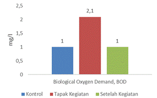
The greater concentration of BOD indicates that the waters are polluted [19]. BOD concentration values ranging from 0-10 mg/l indicate that the waters are lightly polluted; BOD values with concentrations between 10-20 mg/l are categorized as moderate pollution, while >25 mg/l are categorized as high levels of pollution [20].
In measuring the BOD value, it was found that the BOD concentration value in the Paguyaman River was one mg/l – 2.1 mg/l (Figure 6). Following the statement above that, the waters have been lightly polluted. Following the Water Quality Standards (PP No. 22 of 2021 Class II), the BOD value allowed for class 2 is three mg/L, so that value no longer meets the established quality standards. There needs to be an oversight carried out to anticipate more severe water pollution. Moreover, the area passed by this river is a relatively densely populated area.
Figure 6: Measurement of Biological Oxygen Demand (BOD) at the Sampling Point
Chemical Oxygen Demand (COD)
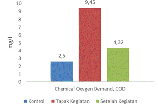
Based on the results of COD measurements, the COD values ranged from 2.6 to 9.45 mg/l (Figure 6). In accordance with PP quality standard No. 22 of 2021, the COD value for class 2 drinks of water is 25 mg/l, so it can be said that the COD value in these waters still meets the quality standard. The higher COD concentration value also indicates that the water has been polluted. The COD value is generally greater than the COD value. This is due to the greater number of organic compounds that can be chemically oxidized compared to biologically [21]. Based on the measurement results, it can be said that the Paguyaman River can still support community farming and animal husbandry activities, but it is no longer suitable for drinking water (Figure 7).
Figure 7: Measurement of Chemical Oxygen Demand (COD) at the Sampling Point
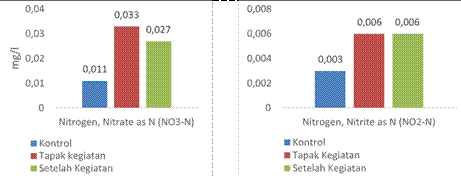
Nitrogen
Nitrogen is oxidized to nitrite and nitrate compounds because nitrite is easily oxidized to a nitrate; the nitrate level becomes higher than the nitrite level. Nitrate compounds can be found in natural waters, which are bacteriological oxidation of nitrogenous materials in the soil. Many nitrate anions (NO3) enter surface water along with domestic water and water from industry, agriculture and others. Nitrates are an indicator of the level of organic pollution from substances containing nitrates [22]. In the sample, the nitrate level is higher than the nitrate. Based on these results indicate that the sample of this study is still within the required threshold (Figure 8).
The total nitrogen oxides (nitrite and nitrate) in the activity site samples had higher total nitrogen oxide levels compared to the control. This is possible from agricultural waste and from the community livestock waste, but it is no longer suitable for the drinking water to be used.
Figure 8: Nitrogen Measurement at the Sampling Point
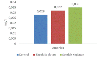
Ammonia
The measured ammonia levels were in the range of 0.028 - 0.035 mg/l. This is certainly not expected by fish farmers, especially fish species that are sensitive to changes in ammonia. In accordance with quality standards based on PP No. 22 of 2021 for class 2, the maximum value of ammonia in waters is 0.2 mg/l, so it can be said that the value of ammonia obtained in the Paguyaman River is high and causes pollution. According to [23], ammonia levels in natural waters are generally below 0.1 mg/l. High ammonia levels can indicate the presence of waste that is discharged into the waters, both from domestic waste and agricultural waste runoff. This is also evidenced by the fact that there are still many community activities originating from agricultural land and also settlements (Figure 9).
Figure 9: Ammonia Measurement at the Sampling Point level. The author also thanks the Head of the KLH
CONCLUSION
Based on the measurement results of several water quality parameters in the Paguyaman River, it can be concluded that the parameters studied still meet quality standards. Some suggestions that can be given based on research results are (a) supervision from agencies related to rock mining activities carried out by companies and communities that have a direct impact on the Paguyaman River. (b) Outreach to communities around the river about or counselling on maintaining and protecting the environment around the Paguyaman River and (c) reviewing and evaluating the granting of rock mining permits around the Paguyaman River.
Acknowledgment
This paper is part of a thesis in the Master's program in Population and Environment State University of Gorontalo. The author would like to thank the Regent of Gorontalo, who has provided the opportunity for the author to continue his education up to the Master's Masters Study Program and all lecturers who have provided useful knowledge. The author's thanks also go to PT Global Quality Analytical, which has assisted in conducting water quality analysis.
REFERENCE
Utami, N.D. and S. Suprayogi. “Study of flood discharge due to changes in land use in the Belik sub-watershed, Special Region of Yogyakarta.” Indonesian Earth Journal, vol. 3, no. 3, 2014.
Permatasari, R., et al. “Effect of land use change on the watershed hydrological regime (Case study: Komering DAS).” Journal of Civil Engineering, vol. 24, no. 1, 2017, pp. 91–98.
Cahyono, Y.E. et al. “Analysis of patterns of land use change in the Biyonga watershed, Gorontalo Regency, Gorontalo Province.” Gorontalo Journal of Forestry Research (GJFR), vol. 4, no. 2, Oct. 2021.
Notonagoro, A.G. et al. Changes in land use and its relation to the hydrological conditions of the Upper Ketahun watershed, Lebong Regency. Thesis, Bogor Agricultural Institute, 2019.
Salote, M.K. et al. “The relationship between the socio-economic conditions of farming communities and land degradation in the Alo Pohu watershed, Gorontalo Province.” Jambura Geo Education Journal (JGEJ), vol. 3, no. 2, 2022. doi:10.34312/jgej.v3i2.14838.
Desey, H. et al. “Strategy for liquid waste management for small and medium industries in North Gorontalo Regency.” RADIAL: Journal of Civilization, Science, Engineering and Technology, vol. 10, no. 1, June 2022, pp. 23–33. doi:10.37971/radial.v10i1.262.
Kojongkam, G.A. et al. “The effect of regional fiscal capacity on climate change action budget commitments.” Golden Ratio of Social Science and Education, vol. 5, no. 1, Apr. 2022. doi:10.32662/golder.v5i1.1996.
Sihombing, P.C. Effect of differences in water temperature on growth and survival of Nile tilapia (Oreochromis niloticus). Thesis, University of North Sumatra, 2018.
Sugianti, Y. and L. P. Astuti. “Dissolved oxygen response to pollution and its effect on the existence of fish resources in the Citarum River.” Journal of Environmental Technology, vol. 19, no. 2, 2018, pp. 203–211.
Handoco, E. “Study of water quality analysis of the Bah Biak River, Pematangsiantar City.” TRITON: Journal of Aquatic Resources Management, vol. 17, no. 2, 2021, pp. 117–124.
Effendi, H. Study of water quality for the management of water resources and the aquatic environment. Yogyakarta: Kanisius, 2003.
Sanger, Y.Y.J. et al. “Effect of land cover type on microclimate in Bitung City.” Agri-SocioEconomics, vol. 12, no. 3A, 2016, pp. 105–116.
Pratiwi, N.T.M. et al. “Periphyton community structure in the Upper Cisadane River, Mount Halimun Salak National Park area, West Java.” Indonesian Journal of Biology, vol. 13, no. 2, 2017, pp. 289–296.
Prasetyawan, I.B. et al. “Measurement of the carbon dioxide (CO₂) system as basic data for determining carbon flux in Jepara waters.” Marina Oceanographic Bulletin, vol. 16, no. 1, 2017, pp. 9–16.
Winnarsih, W. and E. Emiyarti. Distribution of surface total suspended solids in Kendari Bay waters. Doctoral dissertation, Haluoleo University, 2016.
Hauer, F.R. and W.R. Hill. “Temperature, light and oxygen.” Methods in Stream Ecology, 2nd ed., Academic Press, 2007, pp. 103–117. doi:10.1016/B978-012332908-0.50007-3.
Simanjuntak, M. “Dissolved oxygen and apparent oxygen utilization in Klabat Bay waters, Bangka Island.” Marine Science, vol. 12, no. 2, 2007, pp. 59–66.
Dunggio, I. et al. “Impact of pandemic Covid-19 on environment and agriculture in the Province of Gorontalo.” Journal of Ecosolum, vol. 10, no. 1, 2021, pp. 82–88.
Djoharam, V. et al. “Water quality analysis and pollution load capacity of the Pesanggrahan River in DKI Jakarta Province.” Journal of Natural Resources and Environment Management, vol. 8, no. 1, 2018, pp. 127–133.
Salmin. “Dissolved oxygen (DO) and biological oxygen demand (BOD) as one indicator to determine water quality.” Oceana, vol. 30, no. 3, 2005, pp. 21–26.
Yulis, P.A.R. et al. “Analysis of DO, BOD and COD levels in Kuantan River water affected by unlicensed gold mining.” Bioterdidik Journal of Scientific Expression, 2018.
Shah, C.R. “Performance and comparative analysis of SISO, SIMO, MISO, MIMO.” International Journal of Wireless Communications and Simulation, vol. 9, no. 1, 2017, pp. 1–14.
Effendi, H. et al. “Water quality characteristics of the Cihideung River, Bogor Regency, West Java.” Ecolab, vol. 7, no. 2, 2013, pp. 81–92.
Recommended Articles
Research Article
Pulmonary Function Test (PFT) and 6 Minutes’ Walk Test Findings among Interstitial Lung Diseases (ILDS) Patients in a Tertiary Care Hospital
Vir Singh
Published: 27/11/2021
Download PDF
Cite
x
APA
Singh, V. (2021). Pulmonary Function Test (PFT) and 6 Minutes’ Walk Test Findings among Interstitial Lung Diseases (ILDS) Patients in a Tertiary Care Hospital. Himalayan Journal of Community Medicine and Public Health, 2(2), 1-3.
MLA
Singh, Vir. "Pulmonary Function Test (PFT) and 6 Minutes’ Walk Test Findings among Interstitial Lung Diseases (ILDS) Patients in a Tertiary Care Hospital." Himalayan Journal of Community Medicine and Public Health 2.2 (2021): 1-3.
Chicago
Singh, Vir. "Pulmonary Function Test (PFT) and 6 Minutes’ Walk Test Findings among Interstitial Lung Diseases (ILDS) Patients in a Tertiary Care Hospital." Himalayan Journal of Community Medicine and Public Health 2, no. 2 (2021): 1-3.
Harvard
Singh, V. (2021) 'Pulmonary Function Test (PFT) and 6 Minutes’ Walk Test Findings among Interstitial Lung Diseases (ILDS) Patients in a Tertiary Care Hospital' Himalayan Journal of Community Medicine and Public Health 2(2), pp. 1-3.
Vancouver
Singh V. Pulmonary Function Test (PFT) and 6 Minutes’ Walk Test Findings among Interstitial Lung Diseases (ILDS) Patients in a Tertiary Care Hospital. Himalayan Journal of Community Medicine and Public Health. 2021 Jul;2(2):1-3.
Download PDF
Research Article
Silent Threats in the Hills: Assessing Community Awareness of Hypertension and Lifestyle Risk Factors Among Adults in Shimla District
Tejasvin Singh Asi
Published: 25/08/2025
Download PDF
Cite
x
APA
Singh Asi, T. (2025). Silent Threats in the Hills: Assessing Community Awareness of Hypertension and Lifestyle Risk Factors Among Adults in Shimla District. Himalayan Journal of Community Medicine and Public Health, 6(2), 1-7.
MLA
Singh Asi, Tejasvin. "Silent Threats in the Hills: Assessing Community Awareness of Hypertension and Lifestyle Risk Factors Among Adults in Shimla District." Himalayan Journal of Community Medicine and Public Health 6.2 (2025): 1-7.
Chicago
Singh Asi, Tejasvin. "Silent Threats in the Hills: Assessing Community Awareness of Hypertension and Lifestyle Risk Factors Among Adults in Shimla District." Himalayan Journal of Community Medicine and Public Health 6, no. 2 (2025): 1-7.
Harvard
Singh Asi, T. (2025) 'Silent Threats in the Hills: Assessing Community Awareness of Hypertension and Lifestyle Risk Factors Among Adults in Shimla District' Himalayan Journal of Community Medicine and Public Health 6(2), pp. 1-7.
Vancouver
Singh Asi T. Silent Threats in the Hills: Assessing Community Awareness of Hypertension and Lifestyle Risk Factors Among Adults in Shimla District. Himalayan Journal of Community Medicine and Public Health. 2025 Jul;6(2):1-7.
Download PDF
Research Article
Screen or Suffer: Evaluating Awareness of Cervical Cancer and Pap Smear Screening Among Women in Himachal Pradesh
Arshaya Sharma,
Yukti Mahajan
Published: 05/04/2025
Download PDF
Cite
x
APA
Sharma, A. & Mahajan, Y. (2025). Screen or Suffer: Evaluating Awareness of Cervical Cancer and Pap Smear Screening Among Women in Himachal Pradesh. Himalayan Journal of Community Medicine and Public Health, 6(1), 1-6.
MLA
Sharma, Arshaya and Yukti Mahajan. "Screen or Suffer: Evaluating Awareness of Cervical Cancer and Pap Smear Screening Among Women in Himachal Pradesh." Himalayan Journal of Community Medicine and Public Health 6.1 (2025): 1-6.
Chicago
Sharma, Arshaya and Yukti Mahajan. "Screen or Suffer: Evaluating Awareness of Cervical Cancer and Pap Smear Screening Among Women in Himachal Pradesh." Himalayan Journal of Community Medicine and Public Health 6, no. 1 (2025): 1-6.
Harvard
Sharma, A. and Mahajan, Y. (2025) 'Screen or Suffer: Evaluating Awareness of Cervical Cancer and Pap Smear Screening Among Women in Himachal Pradesh' Himalayan Journal of Community Medicine and Public Health 6(1), pp. 1-6.
Vancouver
Sharma A, Mahajan Y. Screen or Suffer: Evaluating Awareness of Cervical Cancer and Pap Smear Screening Among Women in Himachal Pradesh. Himalayan Journal of Community Medicine and Public Health. 2025 Jan;6(1):1-6.
Download PDF
Research Article
Dyspepsia, An Overview With Diet
Ashish Tajne Toofan Chakravarty
Published: 20/08/2025
Download PDF
Cite
x
APA
Toofan Chakravarty, A. T. (2021). Dyspepsia, An Overview With Diet. Himalayan Journal of Community Medicine and Public Health, 2(4), 1-1.
MLA
Toofan Chakravarty, Ashish Tajne. "Dyspepsia, An Overview With Diet." Himalayan Journal of Community Medicine and Public Health 2.4 (2021): 1-1.
Chicago
Toofan Chakravarty, Ashish Tajne. "Dyspepsia, An Overview With Diet." Himalayan Journal of Community Medicine and Public Health 2, no. 4 (2021): 1-1.
Harvard
Toofan Chakravarty, A. T. (2021) 'Dyspepsia, An Overview With Diet' Himalayan Journal of Community Medicine and Public Health 2(4), pp. 1-1.
Vancouver
Toofan Chakravarty AT. Dyspepsia, An Overview With Diet. Himalayan Journal of Community Medicine and Public Health. 2021 Iss;2(4):1-1.
Lahili, R., Lihawa, F. & Dunggio, I. (2022). Performance of Paguyaman Watershed Management Based on Water Physic and Chemistry (Case Study on Metals and Rock Mining Activities). Himalayan Journal of Community Medicine and Public Health, 3(2), 1-5.
MLA
Lahili, Rahmanto, Fitryane Lihawa and Iswan Dunggio. "Performance of Paguyaman Watershed Management Based on Water Physic and Chemistry (Case Study on Metals and Rock Mining Activities)." Himalayan Journal of Community Medicine and Public Health 3.2 (2022): 1-5.
Chicago
Lahili, Rahmanto, Fitryane Lihawa and Iswan Dunggio. "Performance of Paguyaman Watershed Management Based on Water Physic and Chemistry (Case Study on Metals and Rock Mining Activities)." Himalayan Journal of Community Medicine and Public Health 3, no. 2 (2022): 1-5.
Harvard
Lahili, R., Lihawa, F. and Dunggio, I. (2022) 'Performance of Paguyaman Watershed Management Based on Water Physic and Chemistry (Case Study on Metals and Rock Mining Activities)' Himalayan Journal of Community Medicine and Public Health 3(2), pp. 1-5.
Vancouver
Lahili R, Lihawa F, Dunggio I. Performance of Paguyaman Watershed Management Based on Water Physic and Chemistry (Case Study on Metals and Rock Mining Activities). Himalayan Journal of Community Medicine and Public Health. 2022 Jul;3(2):1-5.